Search
Installation of satellite TV
Advertising
Navigation
Main
Satellites
TV Package
HD Channels
Ultra HD Channels
BISS key
Coverage Maps
Sat Receivers
Installation of satellite TV
Satellite News
Contacts
Search
Installation of satellite TV
Advertising
Navigation
Satellite Antenna Alignment - assistance in installing satellite dishes |
Program "Satellite Antenna Alignment" will be hereinafter referred to using the abbreviation SAA is designed to calculate the basic angles that are involved in the installation of a satellite dish. The main difference from other programs - it is possible to calculate the position for all satellites at once. Also, the program will show what satellites can be physically visible from the location of the dish. It should be noted that this program allows you to calculate the direction very accurately.
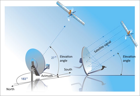 Azimuth - is the direction of the object (satellite) in degrees from 0 (north) and clockwise, is the compass. Elevation - is the direction defined as the angle (in degrees) between the direction of the satellite and the ground plane at the point of reception. If the program issued a negative value - hence, the satellite is below the horizon and the reception of satellites in the area impossible.
To get started with SAA, it is necessary to make initial data- "Coordinates location of the antenna," ie, the geographical coordinates of the place where the antenna is installed.
Symbols in the program: "N-north latitude", "S- south latitude", "E- east longitude" and "W- west longitude." After entering the coordinates in the left side of the table there are computed azimuth angles and lift (elevation) antenna on all satellites.
SAA program uses absolute values ??and calculates the values ??of the angles in accordance with the formulas. Determine the azimuth to the calculated area is easiest with a compass-necessity on-site installation of the antenna housing orient the compass so that the arrow "North" was combined with the zero azimuth scale. An imaginary line that passes through the axis of the arrow, and the division of the scale corresponding to the calculated azimuth, will point the direction of the satellite. However, this method gives a large error. Almost everywhere in the world is different from the magnetic azimuth is the magnetic pole of the Earth's true some do not coincide with the geographical. Also it is influenced by the magnetic compass anomalies -iskazhenie Earth's magnetic field. More customization plate orienting it in the sun at certain times. SAA also helps to calculate the time.
 For example, do the calculation azimuth and space for Intelsat 904 satellite at position 60 ° East. Our conditional Yekaterinburg location. The first step is to determine the coordinates of our location, you can define them using GPS- navigator, physical maps, or by typing in the search engine interneta-: Ekaterinburg Geographical coordinates, latitude and longitude of Yekaterinburg and others. So, we got hold of the coordinates, insert them into the program. Latitude: 56 ° 49 'N Longitude: 60 ° 34 'E Time Zone: GMT +5: 00 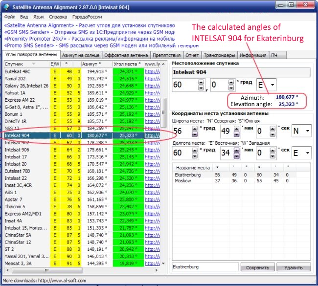 Our calculated angles: Azimuth: 180,677 °, Elevation: 25,323 °
Due to the fact that in recent years widespread Offset satellite antenna, they already have a certain elevation angle (in the range of 20-25 degrees), and for their lifting angle is slightly different. So this angle to determine the program you must enter the dimensions of your antenna offset (height and width), and the program will calculate the exact angle of ascent. This can be done in the "Offset antenna." The calculation is made only for the antenna whose height is greater than width. This tab also shows the angle of elevation to the chosen satellite, and the angle at which you need to actually install the antenna. 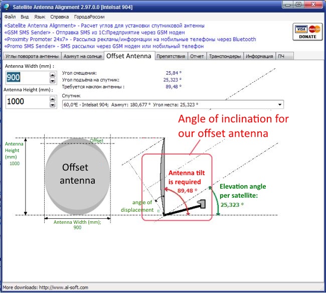 As already stated above, the program allows you to determine the direction of the antenna with the help of the sun, without a compass! The calculation is made for the same geographical coordinates, which we introduced to our area. To calculate go to the tab "azimuth of the sun." The program must specify the date and time zone (the default is the current date), and calculate the movement of the sun in increments of one minute. The calculation results are displayed in the table on the left. For the sun is calculated as the azimuth and elevation angle to the current time.
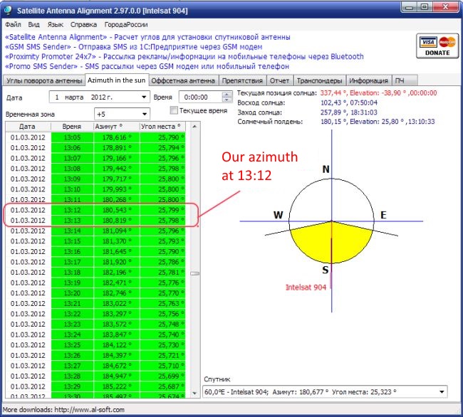 In the left column we are looking for a value previously recorded or stored azimuth. This value must always be on a green background. In the column "Time" will be specified when the sun will be in the same direction as the satellite. The height of the sun above the horizon is determined by the angle of elevation. Sun elevation angle and elevation satellites are likely to be different. For Yekaterinburg, March 1, 2012, the sun will be in the correct position at 13:12, 13:13.
It remains to wait, when the time and location of the satellite dish on the direct sun.
Notes: The calculation is required to specify the time zone (for Yekaterinburg five hours to Greenwich Mean Time). If countries set their clocks to daylight saving time, then to the obtained azimuth calculations necessary to add one o'clock!
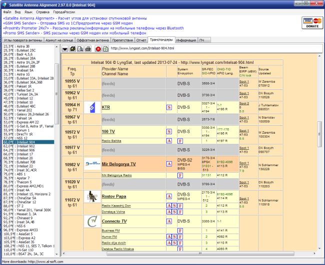
SAA program also allows to calculate the angle between the obstacle to a satellite antenna and a plane conditional horizon, where the antenna is located. By specifying the height of the barrier and the distance to it, you can determine this angle. If this angle is greater than the elevation of your chosen satellite, the satellite reception in the place of installation is not possible. To calculate this angle must go to the tab "Obstacles". 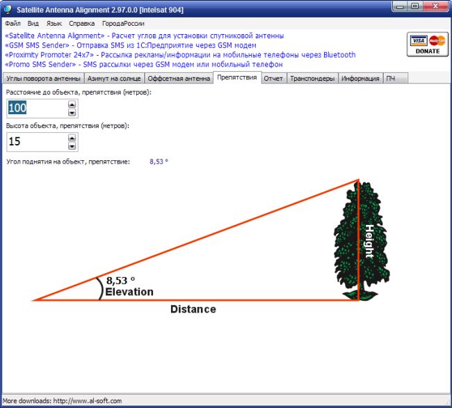 Turning to the tab "transponders", a program downloaded from the Internet all active transponders of the selected satellite. These transponders can be used when setting up an antenna!
We hope that this information will help you understand the options of the program Satellite Antenna Alignment, and make your satellite dish installation quick and pleasant! |
| Arjunan krishnan | (2017-10-28 11:29:31) | 1 |
| Good information thanks |
| Amas farah | (2018-07-13 02:59:18) | -1 |
| Yahsat 52.5 east send me how to install it ? |
| Amas farah | (2018-07-13 02:59:28) | -4 |
| Yahsat 52.5 east send me how to install it |